The objective of GDACS is to assess the overall impact of earthquakes (and eventually associated tsunamis) on affected countries. GDACS alert levels aim at drawing attention to an event that might turn out to be serious enough to require international intervention, or, that could overwhelm national authorities’ response capacity.
JRC has established partnerships with seismological organisations around the world that provide real-time data on earthquakes parameters (magnitude, depth and location). As of September 2017, GDACS included the earthquake intensity calculations (USGS shakemaps [1]) in the alerting algorithm. These parameters are used to establish the affected area and calculate the population nearby. A country-wide vulnerability indicator moderates the alert level to take into account the country-specific vulnerability.
GDACS alert levels aim at classifying earthquakes according to the likelihood that the affected societies can no longer cope at national level and will require humanitarian intervention. The final score then considers the level of coping capacity of the affected country or countries, obtained by the INFORM Index [2]. The coping capacity dimension measures the ability of a country to cope with disasters in terms of formal, organized activities and the effort of the country’s government as well as the existing infrastructure, which contribute to the reduction of disaster risk.
[1] https://earthquake.usgs.gov/data/shakemap/
[2] http://www.inform-index.org/
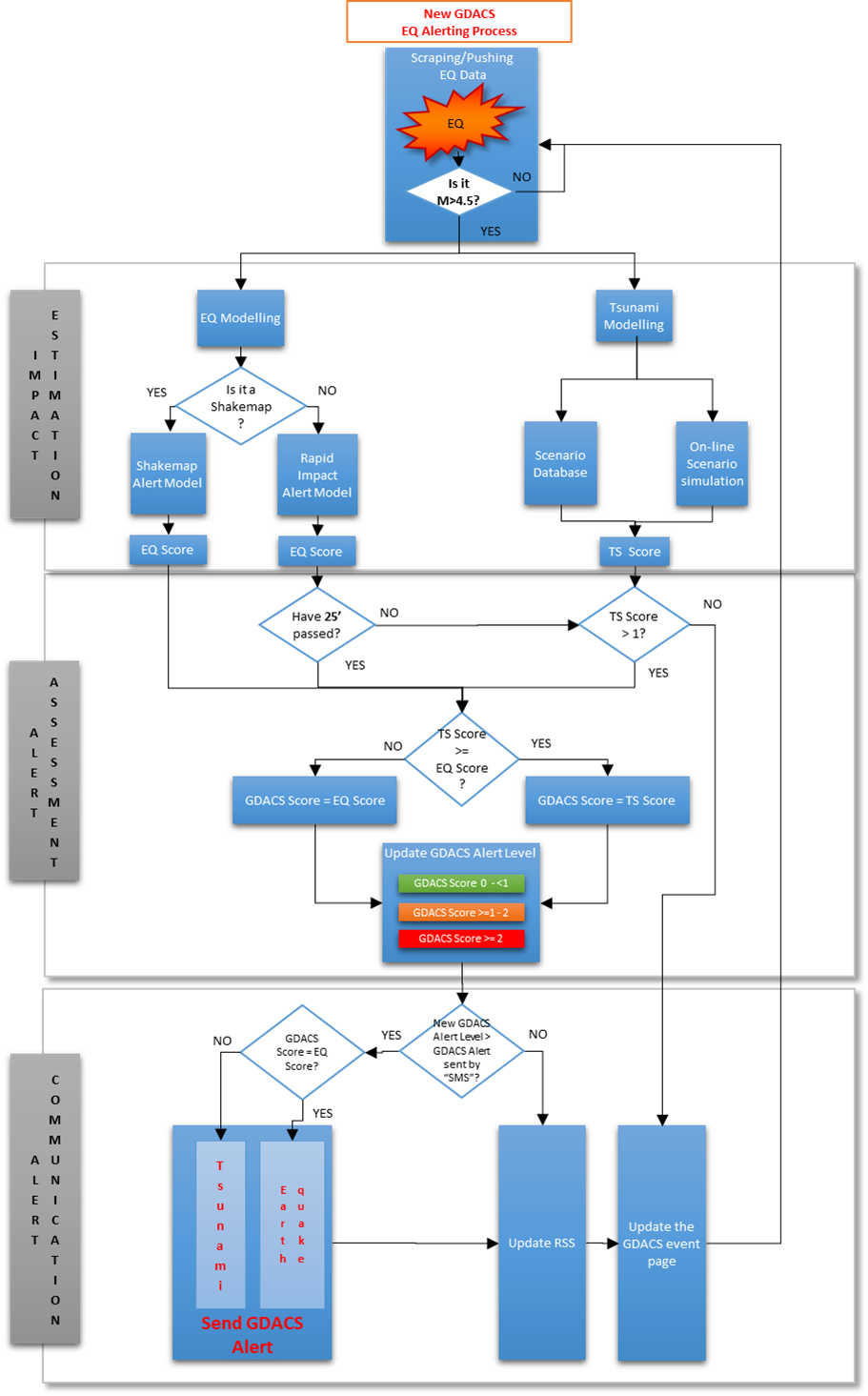
The Earthquake and Tsunami alerting workflow
The seismic alerting algorithm
The earthquake damage considered by GDACS is that caused by shaking or by tsunami. To assess the potential impact by shaking, GDACS considers:
-
Earthquake intensity calculations (USGS shakemaps)
-
Earthquake magnitude
-
Hypocenter depth
-
Distribution of the population within 100km from the epicenter
-
Vulnerability
-
Coping capacity of the affected country or countries (INFORM index)
These data are processed by two different models to calculate the Alert Level (“Shakemap” and “EQ Parameters” Alerting Model). The GDACS seismic alerts are primarily based on the “Shakemap” Alerting Model.
In cases where the shakemap is not available for any reason - usually because the earthquake is lower than 5.5 in magnitude or there have been some delays (e.g. communication problems between the intensity providers and GDACS), the alert score is calculated using only the parameters that are always available: moment magnitude, hypocentre depth and population at various radii from the epicentre.
GDACS “Shakemap” Alert = ƒ (EQ Intensity, Exposed population, Vulnerability, Coping capacity)
GDACS “EQ parameters” Alert = ƒ (Magnitude, Depth, Exposed population, Vulnerability, Coping capacity)
The “Shakemap” alerting model
The GDACS “Shakemap” alerts are based on the geographical distribution of the earthquake’s Modified Mercalli scale intensity (MMI) - what is known as “shakemaps”. A rough map of the intensity of earthquakes stronger than about Mw 5.5 is made available a few minutes after the event, principally by the United States Geological Survey (USGS) but also by other institutes around the world that use the Shakemap USGS software, e.g. the National Institution of Geophysics and Volcanology (INGV) of Italy.
The GDACS shakemap-based alert relies on a score, derived by the number of people exposed in each MMI grade, from VII (Very Strong Shaking) upwards, calibrated by the casualties recorded for all seismic events since 2006 (source: DG ECHO daily flash[1], EM-DAT[2]). In some countries with more than 3 or 4 earthquakes in the record, a more detailed Country-specific coefficients This score has been then re-calibrated separately for each country to obtain country-specific correction from the global trend (“country seismic vulnerability”). In addition to the global score, there are also country-specific scores which have been re-calibrated separately.
More specifically, as soon as GDACs is provided by the shakemap of a strong earthquake (Mw > 5.5) from one of the competent seismological centres, the following sequence is followed:
1. EQ Intensity.
if the maximum intensity in a populated place (i.e. with number of people > 0) is not above MMI VI (Strong Shaking) the GDACS alert is GREEN and the Alert Score is set to 0.
2. Exposed population.
if the maximum intensity is above MMI VI, an expression for weighting the exposed population and a first raw alerting score based on that are calculated:
Scaled Population = 10*Population(MMI IX) + Population(MMI VIII) + 0.1*Population(MMI VII)
and: Raw Score = (-0.59) + (0.53)×log10(Scaled Population)
3. Country seismic vulnerability
A country-specific correction is applied to this score, based on a calibration on the number of casualties by previous earthquakes of similar score in this country since 2006. For most cases this correction is the addition or subtraction of a numerical “Country Shakemap Vulnerability” that can range from -1 to +1 (see table):
Shakemap Score = Raw Score + Country Shakemap Vulnerability
In some countries with more than 3 or 4 earthquakes in the record, a more detailed linear correction is applied, of the form y = ax + b.
The “Shakemap” Score is calculated as follows:
Shakemap Score = (-0.59 + C1Shakemap) + (0.53+ C2Shakemap)×log10(Scaled Population)
At this step, the score lower than 1, corresponds roughly, according to the calibration, to a number of casualties less than 10. A score between 1 and 2, corresponds to casualties between 10 and 100. A score higher than 2, corresponds to casualties more than 100.
4. Coping capacity
to calculate the final Alert Score we apply a factor derived from the Lack of Coping Capacity dimension of the INFORM index (INFORM LCC, yearly updated). A normalisation is applied to the original country-specific INFORM LCC (resulting in values vary by 1.5 of South Sudan to 0.5 of Switzerland, see table). If the score obtained from step 3 is >2.0 (corresponds roughly to a number of casualties of 300) and the final score is <1 due to the country-specific coping capacity, the final alert score is set to 1. This allows to avoid over-estimation of the coping capacity of a country. The final GDACS Alert Score is calculated as follows:
GDACS Alert Score = Shakemap Score * INFORM Lack of Coping Capacity
5. Alert level
Finally, the alert score is transformed into an alert level according to the following thresholds:
| GDACS Alert Level |
GDACS score
(Shakemap)
|
| RED |
≥2 |
| ORANGE |
≥1 - 2 |
| GREEN |
0 - 1 |
In case the event involves 2 or more countries, the highest coefficients within MMI>=7 are considered.
It is worth mentioning that these alerts do not take into account a possible tsunami. Alerting score for the tsunami is calculated separately; see the session on GDACS Tsunami Alert model.
A graph of the “Shakemap” Alerts after all corrections versus the number of people killed for the calibration sample of earthquakes (events between 2006 and 2016 with more than 2 people killed and with shakemap available) is shown below.
Revised GDACS alerts 2004-2016 vs number of deaths by shaking
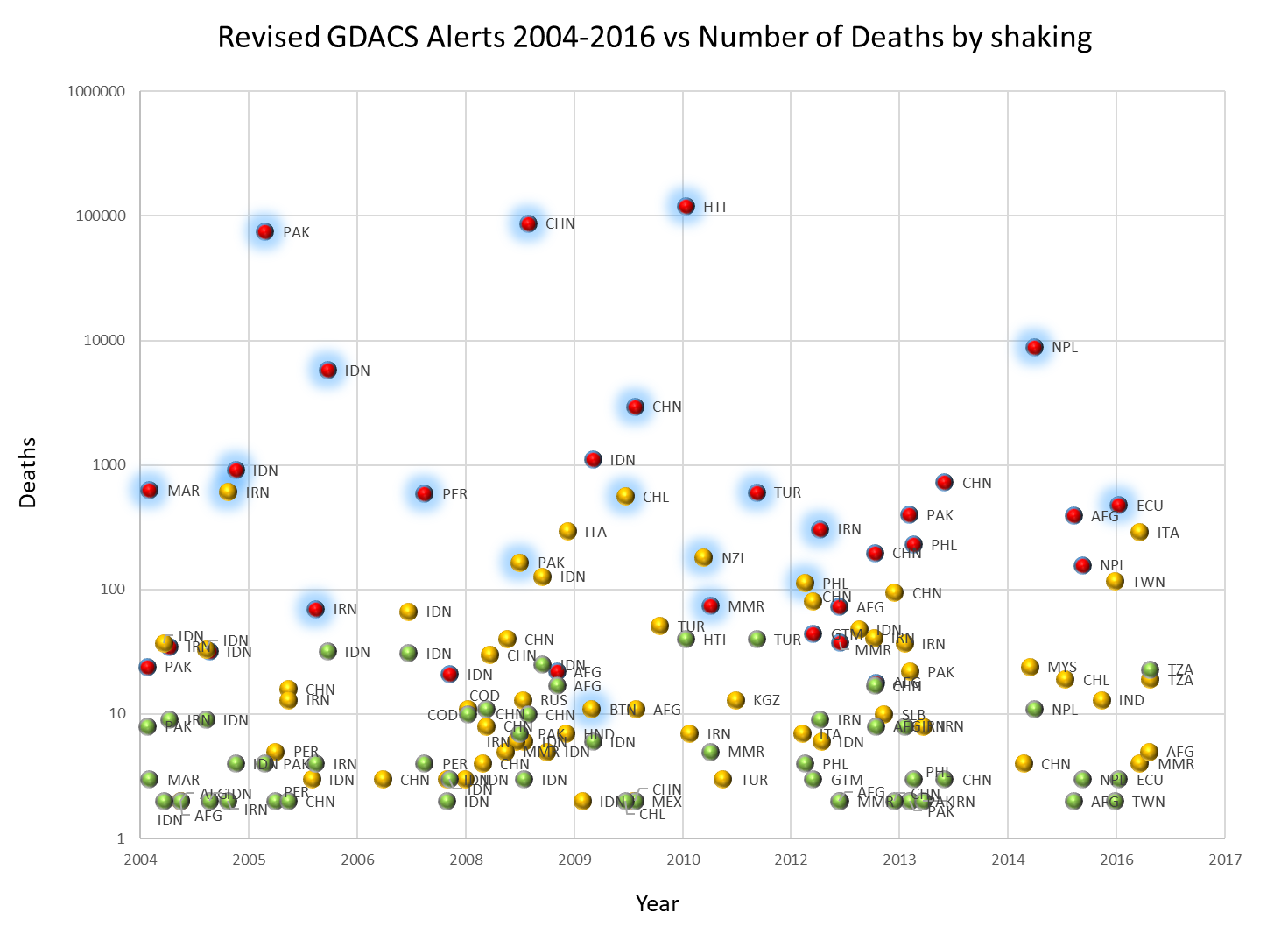
Earthquakes between 2006 and 2016 with more than 2 people killed and with shakemap available. The GDACS alerts have been re-calculated using the “Shakemap” Model. The events that required an international humanitarian intervention are highlighted. (N.B. Number of deaths for tsunamis are not included).
The “EQ parameters” alerting model
In this model, the alert score is calculated using only the parameters that are always available: moment magnitude, hypocentre depth and population at various radii from the epicentre. In the “Shakemap” alerting model, a linear regression model has been applied to all deadly earthquakes with more than 1 fatality since 2006, correlating number of fatalities with magnitude, depth and exposed population. Specific corrections are then applied to each country separately, accounting for the different vulnerabilities.
The steps followed are these:
1. EQ parameters
Moment magnitude (Mw) and depth. The earthquake moment magnitude (Mw) is in unit reported by sources. The alert is based on the last data available at the starting time of the calculation.
2. Exposed population
The exposed population is calculated by the following scaling expression, giving more weight to the exposed population closer to the epicentre:
Scaled Population = 10 * P20 + 2 * (P50 - P20) + 0.5 * (P75 - P50) + 0.1 * (P100 - P75)
where PX is the population at X km from the epicentre. The coefficients 10, 2, 0.5 and 0.1 are such that for a homogeneous population distribution, Scaled Population = P100.
Then the raw alerting score is calculated as follows:
Raw Score = -7.75 + 0.82 * MW - 0.53 * log10(Depth) + 0.72 * log10(Scaled Population)
The coefficients have been obtained by a multi-parametric linear regression model on the number of fatalities against the “Raw Score”, as for the “Shakemap” model.
3. Country seismic vulnerability
A country-specific value is then added to the raw score of each new earthquake and a vulnerability-corrected score is obtained, as in Step 3 above. For countries with a large number of events, a further linear regression is applied that can tighten the correlation of score and number of fatalities (C1Classic, C2Classic, Country Classic Vulnerability, see table). The “Classic Parameters” Score is calculated as follows:
“EQ Parameters” Score = (C1Classic * Raw Score) + C2Classic + CountryClassic Vulnerability
At this step, the score lower than 1, corresponds roughly, according to the calibration, to a number of casualties less than 10. A score between 1 and 2, corresponds to casualties between 10 and 100. A score higher than 2, corresponds to casualties more than 100.
4. Coping capacity
To calculate the final Alert Score we apply a factor derived from the Lack of Coping Capacity dimension of the INFORM index (INFORM LCC, yearly updated) as in the step 4 above. In case the event involves 2 or more countries, the highest value within 100 km is considered. The final GDACS Alert Score is calculated as follows:
GDACS Alert Score = “EQ Parameters” Score * INFORM Lack of Coping Capacity
5. Alert score
As before, the alert score is transformed into an alert level according to the following thresholds:
| GDACS Alert Level |
GDACS score
(EQ parameters)
|
| RED |
≥2 |
| ORANGE |
≥1 - 2 |
| GREEN |
0 - 1 |
Regarding the derived country vulnerabilities by the two methods, it is worth mentioning that while they are quite similar, are not the same, as they have been calculated from very different parameters. In case the event involves 2 or more countries, the highest coefficients within MMI>=7 are considered.
In general, the scores derived by the “classical parameters” method tend to be less accurate, with a higher possibility to over-estimate the impact.
At the same time, the tsunami alert score is calculated (see below).
Results and limitations
Over the years, the GDACS models have been put to the test, with a high user satisfaction. For earthquakes and tsunamis, the most important aspects are timeliness of alerts (as fast as possible) and avoiding false alerts (don’t wake up people if it’s not needed). The first aspect has been improved steadily by forging agreements with regional seismological institutes around the world to push data to GDACS (rather than GDACS scraping data from their web sites). This is most important for timely triggering of tsunami models. The second aspect is ensured by GDACS’s earthquake vulnerability score (which effectively lowers the alert level for countries able to cope with disasters) and the wave-height-based alerting approach for tsunamis (reducing false tsunami alerts by 90%).
Some of the limitations of the approach
GDACS automatic alerts cannot always reliably predict the humanitarian impact of a natural disaster event - this is very difficult to predict even by very sophisticated probabilistic seismic risk assessment tools that take into account detailed exposure and vulnerability data, painstakingly gathered over long time-periods.
GDACS alerting algorithms are empirical in nature and are intended to give a fast and rough warning to people that realise the limitations of automatic systems and of simple “green - orange - red” schemes.
The INFORM Lack of coping capacity Index a simplification of the reality. The main constraints are related to limitations in the methodology and data quality and availability.
Further work
With increasing availability of (real time) data and continuously improving accuracy and detail of models, impact assessment can always improve. GDACS is a collaboration platform open to organisations that have data, models or systems that can significantly contribute towards better impact assessment and new information for emergency responders.
In the past 5-10 years, seismic risk assessment tools have moved into increasing sophistication and detail and are able to take full advantage of the newest developments in hazard, exposure and vulnerability data. All systems are non-commercial and most are open-source and their components can be freely downloaded. The common approach based on the risk equation renders them easily interoperable, but on the other hand this entails significant duplication of effort.
Most systems are either ready or are adapting fast to a real-time use, as early impact assessment and warning mechanisms. Additionally, the lack of accurate globally available exposure and vulnerability data is hampering this effort, so a joint effort to collect these data sets would be an enormous benefit to the global risk assessment and – eventually – risk reduction effort.
JRC, as the scientific lead in GDACS, is interested in exploring integration of such products in the existing impact models.
With regards to earthquakes and tsunamis, we are currently moving towards a more comprehensive and transparent process by:
The inclusion of the output of at least two seismic risk assessment systems in the GDACS events pages with an automatic calculation after an event, or by a manual update by the system developers in a dedicated space.
The integration of probabilistic models and the assessment of the uncertainty, e.g. in relation to the following factors: (i) preliminary uncertainty related to the variation of initial parameters (Mw, depth, location); (ii) number of previous deadly events used to calculate the country seismic vulnerability; (iii) differences in the exposed population due to the use of different global datasets e.g. LandScan and GHSL). This would allow to define and communicate the “alert uncertainty” based on the parameters used to calculate the GDACS alert score.
Additionally, the increase of accurate globally available exposure and vulnerability data is supporting this scope, so the joint effort to collect these data sets is providing an enormous benefit to the global risk assessment and – eventually – risk reduction effort.
